
Open in full screen mode A photo of the oil slick created following a spill at the Hibernia platform, off the coast of Newfoundland , in July 2019. Speech synthesis, based on artificial intelligence, makes it possible to generate a spoken text from written text. Researchers at Memorial University in Newfoundland and Labrador are creating an artificial intelligence tool to spot offshore oil spills more quickly. At present, it is necessary to carry out aerial observations or manually analyze satellite images in order to clearly see the extent of the spills. This laborious and expensive process can take hours or even days and depends in particular on weather conditions. Going to do observations by plane can take days. If we use normal satellite images and analyze them manually, it can take four or five hours, says engineering professor Masoud Mahdianpari. With the method we suggest, you can do it in just an hour. His team's project uses artificial intelligence to quickly analyze images from radar satellites that can see through clouds and haze. The system is configured to detect oil spills based on the shape and texture of slicks spotted with free radar images from the Canadian Space Agency and the European Space Agency. In addition, it automatically monitors a much larger area than is possible with aerial observations. Masoud Mahdianpari is currently participating in Memorial University's Lab2Market Oceans program, which allows researchers to commercialize their ideas by working with marketing and development experts. /p>Loading ELSEWHERE ON INFO: Officials helped Northvolt obtain the green light from Quebec The professor highlights the possible impacts of his project on environmental protection and effectiveness of measures taken to clean up spills. These spills can have a negative impact on marine life. If we can detect and analyze them more quickly, we can potentially reduce the impacts, he says. If it represents an important step forward , the project is not without flaws. Radar imagery works less well if winds blow above 15 km/h. When the sea is too rough, it is more difficult to detect oil slicks. Masoud Mahdianpari acknowledges that the project is probably ill-suited to the context of the Newfoundland oil industry because the existing platforms are located in the middle of the Grand Banks, 350 km from the coast. This sector often experiences very intense storms. The industry is increasingly using artificial intelligence technologies to protect its facilities and the environment. At Memorial University, other researchers are developing an AI tool to protect oil rigs from icebergs.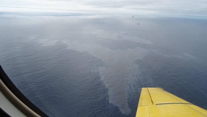
Officials helped Northvolt get the green light from Quebec

By Natasha Kumar
Natasha Kumar has been a reporter on the news desk since 2018. Before that she wrote about young adolescence and family dynamics for Styles and was the legal affairs correspondent for the Metro desk. Before joining The Times Hub, Natasha Kumar worked as a staff writer at the Village Voice and a freelancer for Newsday, The Wall Street Journal, GQ and Mirabella. To get in touch, contact me through my natasha@thetimeshub.in 1-800-268-7116